
DX Monitor Main Window
VE3SUN DX Monitor
Tools for the Intelligent DXer
DX Monitor Main Window
DX Monitor is a standalone Windows program which monitors the DX announcements available on the internet at DX Summit, HB9DRV and connections to an unlimited number of local and international DX Cluster Telnet Servers.
New DX spots are displayed in the main window with user selectable bands, fonts, colors, and highlighting of alerts and local spotters. Beam heading, location (Country or US County), and predicted signal strength can be displayed for each station. Colors and frequencies to hide or show are defined by filters which can be configured using the Filter Editor. A popup menu brings more information about any callsign: history search, maps, web information, free FCC database lookup, Alert List, and more.
The main window can be filtered to show only DX stations with a minimum predicted signal strength (according to VOACAP) at your location, stations on certain bands, or stations spotted by locals. You can even filter the DX by region or country to only show the stations you care about for contests. Beam Heading, Location, and SNR columns are optional.
If your computer is connected to your transceiver, double clicking will tune to the DX frequency.
Click the ![]() Hot Spots Button for a quick list of the hottest DX being spotted now or the 24 Hour Button to analyse all the DX in the past 24 Hours.
Hot Spots Button for a quick list of the hottest DX being spotted now or the 24 Hour Button to analyse all the DX in the past 24 Hours.
Hot spots and DX Alerts of needed stations can be sent by SMS Message to your mobile phone
using the Twitter interface built into DX Monitor.
Band Map
The Band Map is a display of recent spots by frequency. This display is user-configurable in many ways including the length of time to display, the color scheme, and whether to show beam headings and propagation predictions. Recent spots and DX Alerts can be highlighted in different colors. Icons show expected propagation from your location to the DX and whether propagation is improving or declining.
Click here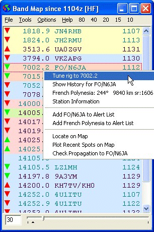
With rig control enabled, the Band Map can act as an intelligent scanner, tuning only to stations with propagation to your location.
The Propagation Chart shows the predicted propagation from your location to the DX Station based on the current sunspot numbers using the VOACAP prediction engine.
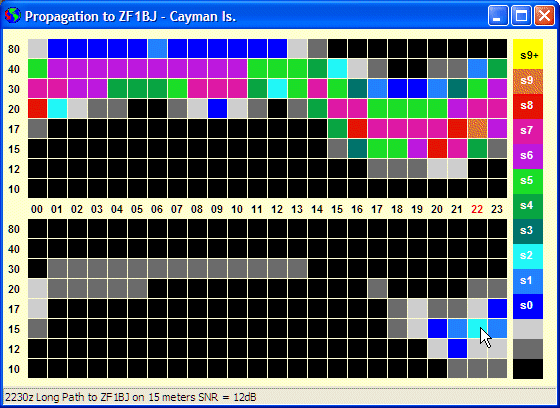
Propagation to the DX from your location
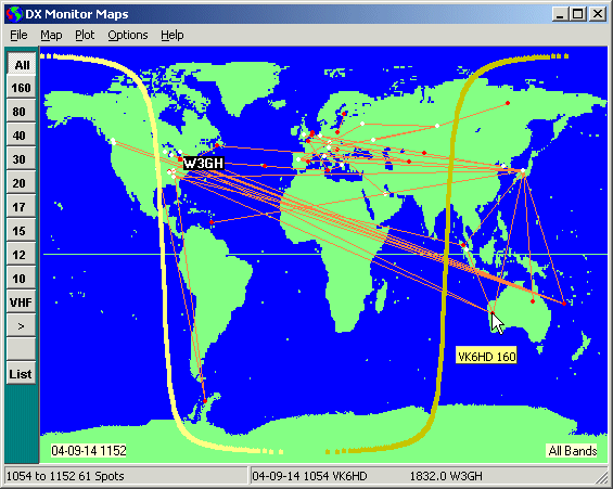
Incoming DX Spots and the entire History Database can be plotted on both Mercator and Azimuthal Projection maps of the world. Click the map for more information on the DX station activity or select from the band and hour filter buttons.
Click Here to read the Maps Help Pages.
Contest and DXpedition logs can be imported and plotted on the maps to be viewed by band and hour using the convenient buttons. Map colors are user defined or satellite imagery can be used as background.
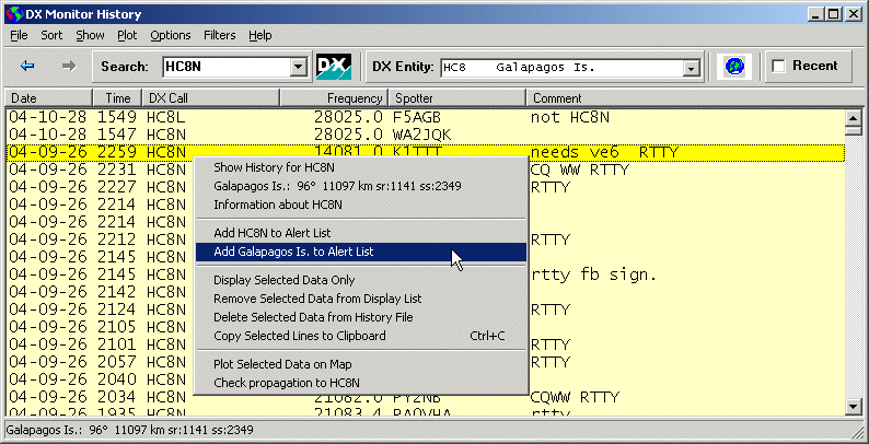
The History Window will show the past history of DX that has been retrieved by DX Monitor. It is the main DX research tool that you can use to discover the operating habits of stations in your needed countries.
Click Here to read the History Window Help Pages.
The operating history of specific stations or all stations from a given DXCC country is at your fingertips. Using the Sort functions and the new tools will help you find a time and frequency to look for the DX before the pileups begin.
Your own contest logs can be imported and analysed using the tools in the Sort and Show menus.
Check out the analysis of the 3Y0X DXpedition.
Click on the WWV button, the WWV number panel, or open the WWV History Window from the Window menu to view the WWV History and Forecast window which shows the current WWV numbers along with 3 cycles of history and NOAA forecasts.
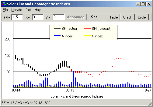
Click Here to read the WWV Window Help Pages.
Station Information Window
The Station Information Window centralizes all the information sources about a particular callsign. First, it will perform a lookup on various databases on CD or your hard drive. At present, the RAC Callbook, HamCall and the free K4HAV FCC/VE Database are supported. Quick buttons will search for information on the QRZ and HamCall web sites or Google for other sources. Notes may be taken which will be displayed any time the callsign is entered.
The address or the latitude/longitude can be used to find the station location using Google Maps or the Google Earth application via the Tools Menu.
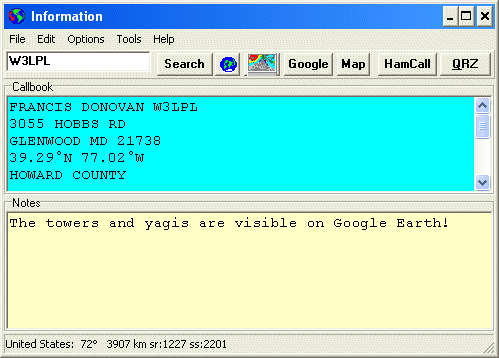
Station Information Window
Press F11 to open the Station Information Window from other windows. If a callsign is selected, it will be automatically shown in the edit box. Station Information is also available on many of the right-click popup menus throughout the program.
A quick look at the operation of a station, country or any other data collected in the History database. Activity can be plotted by hour or by day of the week, useful for determining whether needed DX stations are on every day.
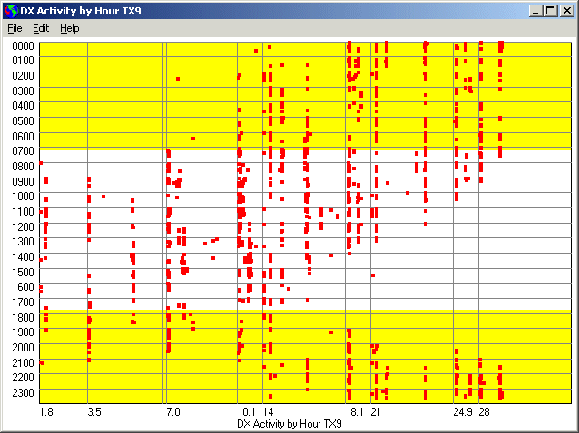
Scatter Chart of Hourly Operation for YV0D
The yellow represents daylight hours at your location, giving you a quick idea of when good propagation on a band coincides with the DX station’s activity.
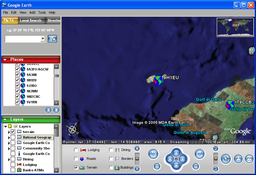
If you have the Google Earth application installed, DX Monitor can create an animated DX Tour of the world based on the spotting history or your own logs. As a screen saver, Google Earth will fly the real time DX spots as they arrive and tune your receiver to each station.
Try the Sample Tour. Click the link, wait for Google Earth to finish loading, then press F10 in Google Earth to start the tour.
DX Monitor is distributed as shareware. Registration of the program is required for use beyond the testing period. You may register and pay for DX Monitor on the DX Monitor Registration Page. Thank you for your continued support.